


The Liquid Timeline: 30 Kilometers of History
From the Rough Waves of the Black Sea to the Serenity of Marmara
The Bosphorus is a geographical anomaly. It is a 30-kilometer-long natural fissure that splits a single city into two continents. Navigating this strait is like reading a history book from cover to cover; starting with the rugged fortifications of the North and ending with the imperial silhouette of the Historical Peninsula in the South.
The Three Necklaces of Istanbul
Connecting Europe and Asia requires more than asphalt; it requires defiance against gravity. Three monumental suspension bridges span the strait, each representing a different era of the city’s expansion, from the rugged Black Sea entrance to the urban heart
 The Gateway
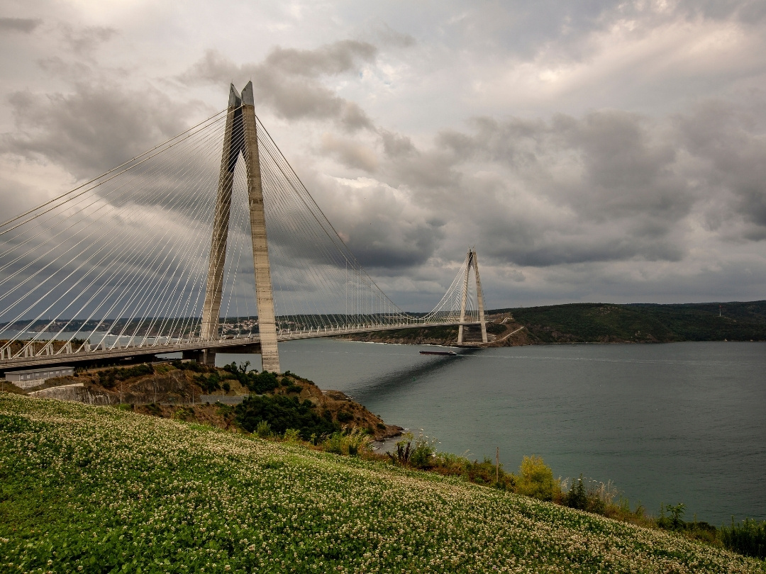
The North: Yavuz Sultan Selim
Standing at the very mouth of the Black Sea, this is the widest suspension bridge in the world. It marks the wild, rugged entrance to the strait where the currents are strongest.
 The Hinge
The Middle: Fatih Sultan Mehmet
Located at the narrowest point (Aşiyan), spanning between the two fortresses. It acts as the hinge of the city, connecting the hills of Europe and Asia.
 The Icon
The South: 15 July Martyrs (Bosphorus Bridge)
The first link built in 1973. It is the emotional anchor of Istanbul, framing the view of Ortaköy Mosque and welcoming ships into the city center.

The Bosphorus is not a straight line; it is a sharp "S" shape. The most dangerous point is the Yeniköy Turn, requiring a blind 80-degree maneuver. Large tankers must practically drift sideways to avoid hitting the historic yalı mansions on the shore.
Enrich Your Exploration

Four Seasons:
Bosphorus, Perfected

Garenta: Discover More of Istanbul
the landmarks; experience the
real city. Garenta offers the freedom to discover Istanbul's hidden treasures at your own pace.
Sarayburnu: Where the Strait Ends
As the current pulls you south, the modern city fades, and the silhouette of the Ottoman Empire rises from the mist. This is the junction where the Bosphorus yields to the Sea of Marmara, crowned by the walls of Topkapi and the domes of Hagia Sophia.

The Northern Guardians: Rumeli & Anadolu Feneri
Before the bridges, ships are greeted by two historic lighthouses at the mouth of the Black Sea. This is where the water is roughest and the wind strongest—the official entrance to the Bosphorus system.


Journey with Confidence
Acıbadem Hospitals Group: Global Excellence in Healthcare
While you immerse yourself in the rich history of Istanbul, your well-being is protected by a future-focused healthcare leader. Acıbadem provides world-class medical services, from comprehensive health screenings to advanced treatments, all delivered with a commitment to your safety and comfort.
Travel with the assurance that you and your loved ones are in the most capable hands.
The Golden Horn Junction
Just before the Bosphorus ends, it creates a natural estuary that cuts into the European side. Known as “Haliç,” this calm harbor was the naval heart of both the Byzantine and Ottoman Empires.
 Natural Harbor
Where the Waters Fork
The strategic "Golden Horn" serves as a calm refuge from the strong currents of the Strait. Historically, an immense iron chain was stretched across this junction to stop enemy ships from entering the harbor.
FAQ: Frequently Asked Questions about Istanbul Bosphorus
How long does it take to travel the entire Bosphorus by boat?
A continuous ferry ride from the Eminönü pier (South) to Anadolu Kavağı (North) takes approximately 90 minutes one way. This “Long Bosphorus Tour” is the classic way to see the transition from urban palaces to fishing villages.
Why are large tankers accompanied by tugboats?
Due to the strong currents and sharp turns, maritime law requires large vessels carrying hazardous materials to be escorted by tugboats (coastal safety units). These tugs are ready to push the ship back on course if the current drags it towards the shore.
What is the "Golden Horn"?
The Golden Horn (Haliç) is a natural estuary that branches off from the Bosphorus at the southern end. It acts as a natural harbor and historically separated the “Old City” (Constantinople) from the “New City” (Galata/Pera).
Are there underwater tunnels crossing the strait?
Yes. Besides the three bridges above, the continents are connected below by the Marmaray (rail tunnel) and the Eurasia Tunnel (road tunnel), engineering marvels built deep within the seabed rock to withstand earthquakes and water pressure.
What is the best time of day to navigate the strait?
Sunset is universally considered the magical hour. As the sun dips behind the Historical Peninsula, the water turns a deep gold, and the silhouettes of the mosques create the iconic Istanbul skyline that has inspired painters for centuries.
